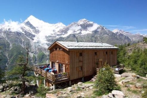
Europahutte is the trail to the Europa hut that starts at Randa in the valley floor and leads across the Dorfbach river before climbing steeply to the hut at 2220 meters. The Europaweg forms part of the Tour Monte Rosa. The suspension bridge over the Dorfbach river above Randa is closed, and will not reopen again for safety reasons. Hikers therefore cross the river down in the main valley before climbing straight up to the hut with an ascent of 909 vertical meters. This beautiful walk to Europahutte starts at Randa and ends at Randa with total distance of 7.48 kilometers taking approximately 3 hours and 45 minutes. The highest point on this trail is at 2264 meters with an ascent of 909 meters and descent of 909 meters.
The Flower trail is a real treat for anyone who loves flowers. Depending on the season, walkers may see blossoming edelweiss and gentian as well as many other alpine flowers. This walk will delight all who enjoy admiring flowers or have a special interest in alpine flora. Numerous information panels give details of the alpine flowers growing close by. The boards answer questions that may won’t have even asked themselves, such as why does the edelweiss have fleecy hairs. The answers come as a surprise. The edelweiss’s hairs, for example, protect it from sun damage, frost and drying out. This beautiful and refreshing trail starts at Blauherd and ends at Sunnegga with total distance of 4.59 kilometers taking approximately an hour and 20 minutes. The highest point on this trail is at 2574 meters with an ascent of 152 meters and descent of 442 meters.
The hike from Furi to Stafel is best for early risers with beautiful sunny route in the morning. In the afternoon, the second part of the walk is already in shadow. The start of the path in Furi, however, is sunny where the view back down to Zermatt shows hikers that they have already climbed a fair way, thanks to the gondola. The gentle route then follows the agricultural road to Stafel. The trail is mostly shady, but very relaxing where the cold air has a calming effect. The path climbs steadily. At Stafel, the mighty north face of the Matterhorn dominates the scene, where sometimes a cold, piercing wind blows but hikers have the chance to stop for a warming drink or delicious meal. This very relaxing trail starts at Furi and ends at Stafel with total distance of 4.85 kilometers taking approximately an hour and 40 minutes. The highest point on this trail is at 2200 meters with an ascent of 452 meters and descent of 124 meters.
