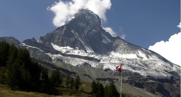
The Matterhorn, local name “Hore”, is in motion. In 2003, rockslides from the Hornligrat ridge attracted international attention. The Matterhorn has long been under scientific observation. Scientists state that rockslides have always been a possibility and are keeping an eye on the mountain of mountains in order to understand the mechanisms at work. If spring and summer are very warm, the events of 2003 could well be repeated. Meaning there could be more rockslides on the Hornligrat. On July 15th 2003, around 1000 cubic meters of rock came down. Over 90 mountain climbers had to be helicoptered off the mountain and the climbing route was closed for several days. The rock mass of 1000 cubic meters is equivalent to a cube with a size of 10x10x10 meters.
For several years, a network of wireless sensors has been supplying data on rock movement on the Matterhorn. Researchers from the National Center of Competence in Research or Mobile Information and Communications System (NFS MICS) are now publishing their findings, which are helping to better understand rockslides and monitor risk zones in areas of permafrost.
In a media release, the SNSF (Swiss National Science Foundation) goes into detail about the mechanisms. The Alpine landscape will undergo great transformation in coming decades as a result of global climate change. The glaciers will recede even further and the number of rockslides must be expected to rise. Experts have been recording an increase in such events in the Alps for several years. This applies in particular to areas of permafrost, where the bedrock is permanently frozen. A rockslide occurred on the Hörnligrat ridge of the Matterhorn in the hot summer of 2003. Inspection of the breakaway point showed that the rockslide had exposed various frozen fissures. A team of researchers around Stephan Gruber from Zurich University thus took a more in-depth look at the unstable area on the Matterhorn.
In summer 2007, Gruber’s group, together with scientists from Basel University and the Swiss Federal Institute of Technology in Zurich, installed a network of wireless sensors on the Hörnligrat ridge. This was within the framework of the PermaSense project by the National Centre of Competence in Research «Mobile Information and Communications Systems» (NFS MICS) and also funded by the Swiss Federal Office for the Environment. The network allowed researchers to measure rock movement in the various fissures over several years. The researchers state that they determined a complex pattern of movement apparently influenced by two factors. When the rock warms in summer, it expands and closes the fissures. When the rock cools again in autumn, it contracts and the fissures reopen. This expansion and contraction gradually changes the geometrical arrangement of the fissure, with the result that over a period of time, the rock loosens.
The measurement data of recent years gives them valuable information to better understand the processes in areas of permafrost. It helps them with the long term and targeted monitoring of danger zones. Frozen rock tends to be less stable in warmer temperatures is an obvious hypothesis. But they only know the basics of what is taking place underground.
