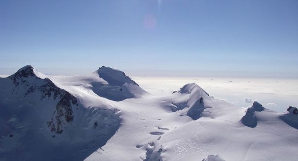
Ludwigshohe stands on the border between Switzerland and Italy and it is one of numerous peaks in the Monte Rosa massif, and the most southerly 4000 meter summit in Switzerland. The Ludwigshoehe is a small mountain compared to other peaks of the Monte Rosa massif. Here there is about 40 kilometer long mountain range which separates the valleys of Seisa and Gressoney which leaves from the main ridge of the alps. In this range there is the next 4000 meter peaks of Schwarzhorn/Corno Nero and Piramide Vincent and later on the Corno Bianco. Further to the south-west, the range spreads wide and builds an area through which are some parts of the mountain trail.
The Ludwigshohe is one of the ten 4000 meter summits of the Monte Rosa massif. And it stands on the borders between Italy and Switzerland, and between the Valle d’Aosta and Piedmont regions. On the Italian side, to the south-east, the mountain falls away steeply to the Ghiacciaio delle Piode. The Monte Rosa massif has about ten peaks above 4000 meters and they are Dufourspitze, Grenzpigfel, Ludwigshohe, Nordend, Parrotspitze, Schwarzhorn, Signalkuppe, Vincent Pyramid, and Zumsteinspitze. The Ludwigshohe was first climbed on August 25th 1822 by a team of surveyors for purely scientific reasons. Ludwig Freiherr von Welden, the Austrian general and topographer who led the expedition, named no fewer than eight peaks in the Monte Rosa massif. As was generally the case in the early 19th century, no names or scientific descriptions existed for these. Von Welden determined the location, named and height of the summits in words, pirctures and on maps. He was also the first to draw up a map of the complete Monte Rosa massif.
The name Ludwigshohe is from the first ascent that took place on the feast day of the canonised French king Louis IX who died on August 25th 1270. Ludwig von Welden gave this name rather than his own identical name and called it the peak Ludwigshohe or Ludwig’s summit. To reach the summit hikers can go from the north-east plain between Ludwigshoehe and Parrotspitze, or from north-west where the normal route from Capanna Gnifetti to the Signalkuppe/Punta Gnifetti crosses the Italian-Swiss border or from south-west from the saddle which separates it from the Corno Nero. Either way hikers choose, it is not a difficult trail and it should only take some minutes to reach the summit. But gears for glacier walk is necessary.
