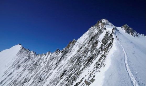
The Nadelhorn has an unusual feature with a hole through the rock, just a few meters below the summit. However, it is visible only to mountaineers climbing the neighboring Dom. At 4327 meters, it is the third elevation of the Mischabel Chain and it is very popular in the Saas Valley, even if geographically it is closer to the Mattertal where its ridge continues toward. It lies north of the Dom de Mischabel between the Lenzspitze and the Stecknadelhorn.
The Nadelhorn forms part of the Nadelgrat ridge. This links the Lenzspitze, Nadelhorn, Stecknadelhorn, Hohbarghorn and Dirruhorn all which are 4000 meter peaks. These lie somewhat hidden, extending north-west from the Mischabel group, between Saas Fee and Randa. Their traverse is considered one of the finest ridge climbs in the Alps. There is a distinctive rock hole below the summit. The Nadelhorn can be scaled on skis in winter from the Brodier hut via the Windjoch col. The people of Savoie called Mont Blanc the “Mont Maudit” or the cursed mountain. Is it any surprise, then, that the early inhabitants of the Saas valley likened the peaks of the Mischabel massif to a pitchfork. The names of the Nadelhorn and Nadelgrat do not refer to the point of a needle but to a cleft near the summit that suggests the eye of a needle. But what is the connection between a pitchfork and the eye of a needle? The first people to scale the Nadelhorn actually came to set up a trigonometric measurement point, climbing further, they found themselves unexpectedly on the summit. The first ascent followed an expedition to set up a trigonometric measure point. The snow covered northern flanks of the Nadelhorn form the top of the Ried Glacier, the Hohbalm Glacier extends to the east.
The name “Nadel” meaning needle clearly deserves the name because the summit clearly looks like a needle when seen from the north. However, the name originates from an oval hole the “Nadelloch”, clearly visible from the Festijoch col on the ascent to the Dom. The hole is located about 10 meters north-west of the summit. On certain days of the year, the sun shines through the rock hole.
The north-east ridge is called Windgrat, and it is snowy and sweeter than the other two. It’s lowest point arrives at the Windjoch and then gains height again up to the Ulrichshorn. The south-east is steep, sharp and aerial and completely rocky. It links the Nadelhorn to the Lenzpitze, one of the most difficult mountains of the group allowing an amazing traverse. The north-west is the most interesting one which presents many features of the Peuterey Ridge of the Monte Blanc like very sharp steeples, cracks and vents. In fact it is constituted by a series of sharp peaks, culminating in the Nadelhorn, the complete ridge runs between the Nadelhorn and the Hohberghorn which the steeple of the Stecknadelhorn in the middle, and other two sharp peaks called Zwillingen.
